Andhra Pradesh (AP) is the fifth largest State in the Indian Union having an area of 275,909 sq. kms and a population of about 75-80 million. AP is bound in the North by Orissa and Madhya Pradesh States, in the East by bay of Bengal with a 960 km long coast line, in the South by Tamilnadu State, and in the West by Karnataka and Maharashtra. AP forms a major link between the north and the south of India. ANDHRA PRADESH
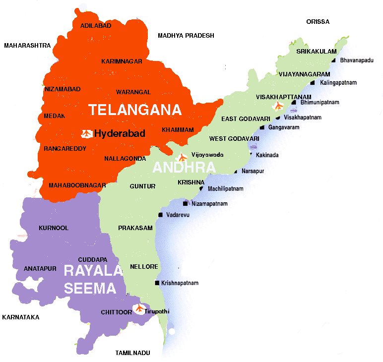
Andhra Pradesh consists of three distinct regions, namely, Andhra, Rayalaseema and Talangana. Andhra and Rayalaseema were part of Madras province of the British empire. For approximately 400 years, Telangana was part of Hyderabad State, an independent kingdom ruled by Muslim Qutub Shahi and Nizam dynasties. Thanks to the sacrifice of Sriramulu Potti, Andhra and Rayalaseema were separated from Madras State in 1953. Andhra state (Andhra and Rayalaseema) was the first state that was formed purely on linguistic nationality, like many European states. Later Andhra merged with Telangana in 1956, based on their linguistic and national affinity, to form the present state of Andhra Pradesh, Hyderabad as the capital city. However, this has resulted in two major agitations: Jai Telangana in 1969 and Jai Andhra 1972, both for separate states.
The Krishna and the Godavari are the major river systems in AP. The Godavari is the largest and the broadest river of South India.
States like Tamil Nadu, Karnataka, Maharashtra, West Bengal etc. have produced and published comprehensive histories and cultures of their respective people. Several minor and major European nationalities have done the same. For some strange reason, comprehensive histories of Andhra, Rayalaseema and Telangana peoples and their cultures have remained a dream, long cherished but unfulfilled. (Some history of AP can be reviewed at: http://www.andhrapradesh.com/apwebsite/hist&culutre/history2.html, http://www.andhraachuki.com/satavahanas.htm, http://www.shubhyatra.com/htm/andhrapradesh/history.htm)
Andhra is also known as Coasta, meaning coastal region. Andhra constitutes: Srikakualam, Vijayanagaram, Visakhapatnam, East Godavari, West Godavari, Krishna, Guntur, Prakasham, and Nellore districts. Andhra is the most advanced region in Andhra Pradesh, both economically and educationally.
District
Population
Area (sq. km) Capital
Srikakulam
2,321,130
5837
Srikakulam
Vijayanagaram
2,110,943
6,539
Vijayanagaram
Visakhapatnam
3,285,092
11,161
Visakhapatnam
East Godavari
4,541,220
10,807
Kakinada
West Godavari
3,517,568
7,742
Eluru
Krishna
3,698,833
8,727
Machilipatnam
Guntur
4,106,999
11,391
Guntur
Prakasam
2,759,166
17,626
Ongolu
Nellore
2,392,260
13,076
Nellore
Andhra 28,733,211 92,906
Rayalaseema constitutes: Kurnool, Kadapa, Anantapuram, Chittooru.
District
Population
Area (sq. km) Capital
Kurnool
2,973,024
17,658
Kurnool
Anatapuram
3,183,814
19,130
Anatapuram
Kadapa
2,267,769
15,359
Kadapa
Chittore
3,261,120
15,152
Chittore
Rayalaseema 11,685,727 67,299
Telangana forms the core of the Satavahana Dynasty (221BC-218 AD) and in the recent history, it formed the core of the Golconda State and Hyderabad State, ruled by alien Muslim rules, Qutub Shahi Dynasty (1520-1687) and Nizam Dynasty (1724-1948), until she joined the democratic republic of Indian Union in 1948 ending hundreds of years of autocratic rule. Despite fifty-years of democratic rule, the Telangana region remains one of the most backward rgions in the entire Indian Union and remains the most backward province in the state of Andhra Pradesh. Telangana constitutes 10 districts: Adilabad, Karimnagar, Nizamabad, Medak, Warangal, Khammam, Hyderabad, Rangareddy, Nalgonda, and Mahaboobnagar districts.
District Population Area (sq.km) Capital
Adilabad
2,082,479
16,105
Adilabad
Karimnagar
3,037,486
11,823
Karimnagar
Warangal
2,818,832
12,844
Warangal
Khammam
2,215,809
16,029
Khammam
Nalgonda
2,852,092
14,240
Nalgonda
Mahaboobnagar
3,077,050
18,432
Mahaboobnagar
Medak
2,269,800
9,699
Sangareddy
Nizamabad
2,037662
7956
Nizamabad
Hyderabad
3,145,940
217
Hyderabad
Rangareddy
2,551,966
7,493
Hyderabad
Telangana 23,873,307 98811
Please Visit:
Mana Sansktiti (Our Culture),
a monthly journal, for articles on the history, culture
and literature of Andhra Pradesh
Related Websites